: Passing null to parameter #1 ($string) of type string is deprecated in <b>/home/u410523311/domains/greenwebmonster.com/public_html/news/wp-content/themes/Newspaper/loop-single.php</b> on line <b>64</b><br />")
[ad_1]
A developing tropical storm is set to bring “life-threatening” impacts to the Carolinas and Mid-Atlantic beginning Friday and lasting through the weekend.
Threat level: The biggest risks from what may be named Tropical Storm Ophelia later Friday are coastal flooding, high winds and copious amounts of rainfall.
- The storm is intensifying on Friday while taking on more characteristics of a tropical storm.
- Regardless of the classification of this weather system, it is likely to be as impactful as a strong tropical storm, particularly from eastern North Carolina northward to coastal New Jersey.
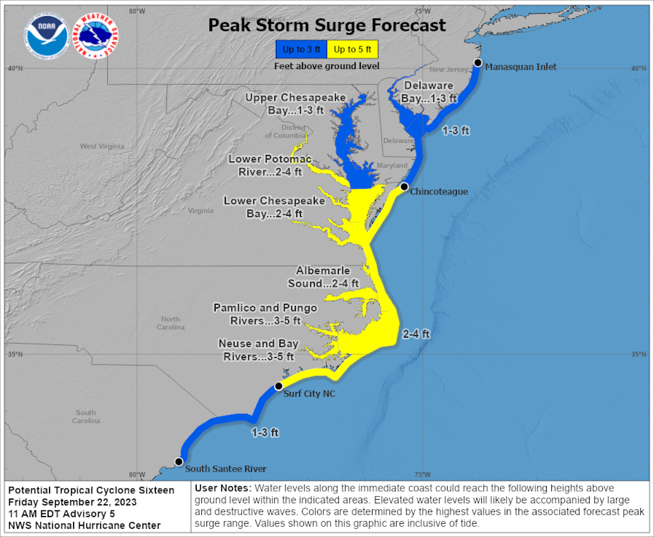
- The National Hurricane Center is warning of life-threatening storm surge flooding along coastal areas of North Carolina, Virginia, parts of Maryland, Delaware and New Jersey, where storm surge warnings and watches are in effect.
- Storm surge refers to a rise of water, typically driven by a storm’s winds, above the predicted astronomical tide levels.
Zoom in: The areas expected to be hit hardest include parts of southeastern North Carolina, where 3 to 5 feet of surge is expected.
- Norfolk and Virginia Beach, Va., an area especially vulnerable to coastal flooding, is expected to see 2 to 4 feet of storm surge.
- The Upper Chesapeake Bay region and much of coastal New Jersey is in a region that is forecast to see 1 to 3 feet of surge.
The big picture: The storm is gaining energy from the Gulf Stream as well as winds in the upper levels of the atmosphere as well. It is likely to make landfall in eastern North Carolina on Saturday, and then weaken while moving north-northwestward into the Mid-Atlantic.
- As it does so, it is likely to spread a shield of heavy, windswept rains from the Carolinas to southern New England.
- Washington, D.C., for example, could pick up as much as 4 or more inches of rain between Saturday and Sunday, along with gusty winds and a threat of coastal flooding along the tidal Potomac River.
- The National Hurricane Center is predicting that the storm will have maximum sustained winds of 65 mph when it makes landfall, bringing with it the threats of downed trees and power lines.
Our thought bubble: This storm is not one that has been heralded in the media for days, spurring evacuations and planning. It may surprise many with its significant impacts, particularly because it will be making landfall as it intensifies.
[ad_2]
Source link